
Having Mobile Mapping surveys of the road network is a valuable source of information to improve and enrich the cartographic bases. Quality and properly georeferenced data are the result of the work carried out using this disruptive technology. To achieve this, 1: 5,000 scale maps are key. In this article we will tell you everything they contribute to these cartographic representations.
Reviewing concepts: Mobile Mapping
Looking back, it’s a good time to remember what exactly Mobile Mapping technology is. It is a set of techniques that allow, roughly, to take geolocated photos, to generate point clouds with lasers and other types of data of special interest with a strong geographical component.
All this is achieved with a device that includes cameras, which can even take 360º photos, location systems (GPS), navigation and laser scanners. A display that is placed on a mobile support, such as a car.
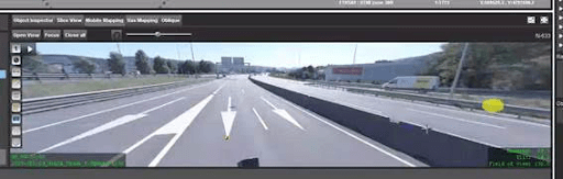
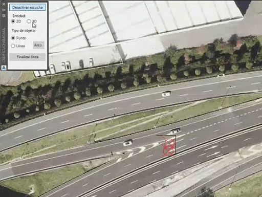
To achieve optimal productivity in the digitization process from Mobile Mapping data, tools that manage images and point clouds are used with the ability to automatically digitize the white lines and transfer the drawn elements to the CAD environment.
What advantages does Mobile Mapping provide in cartography at a scale of 1:5,000?
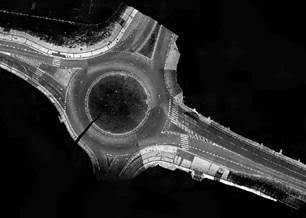
Mobile Mapping technology has been shown to achieve accuracies equivalent to a 1: 1,000 scale or higher, making it an optimal data source for improving 1: 5,000 scale mapping.
These scales are very useful for topographic studies, through which elements of the road network, infrastructures, buildings, reliefs, hydrography, administrative boundaries, etc. can be represented on maps.
What advances does the incorporation of Mobile Mapping technology represent for representations at a scale of 1: 5,000? Among the possibilities for improvement, the following stand out:
- The replacement of the roadsides by the white lines of the road digitized from images.
- The geometric revision and correction of the constructions that are in the margins of the highway by means of comparison with intensity orthophotos.
- The improvement of the contour lines and the substitution of the elevation points on roads from the point cloud obtained.
With the improvement of the accuracy of the 5,000 geographic base in the road environment, the possibilities of using it increase, as it can be combined with the asset inventories obtained from the Mobile Mapping Data.
In this way, road management optimization is achieved, working from accurate, quality, current and more accessible digitized information regardless of time and location.
Thus, effective improvement and maintenance tasks will be proposed, in addition to reducing field work, with its consequent costs and inherent risks for the operators who are in charge of them.
As you can see, the benefits of using Mobile Mapping are the most attractive for the administration of the road network. If we have convinced you to think about using this technology, from Geograma we are more than willing to help you develop the project you need.
In fact, we are pioneers in its application. Works such as the one carried out for the roads of Malta or for the analysis of the urban environment of San Sebastián / Donostia (Portal “Donostia Oinez”) support it.
Can you tell us your case and we get to work? Contact us.