
Cut the risk and cost of evolving your data models.
MetaMod structures the knowledge of your models so you document once, speed up interoperability and use AI without exposing records.
Specialised in geospatial information and integrable with your current platforms.
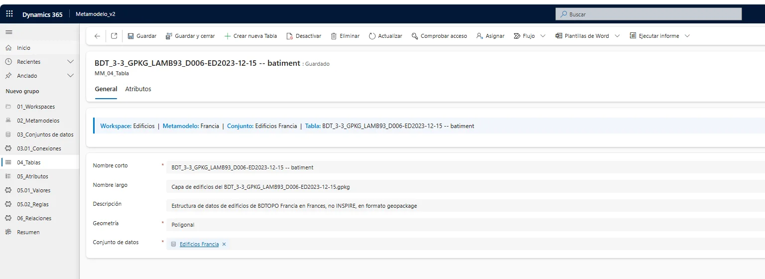
Real product screenshot
All the knowledge of the model, in a single framework
MetaMod is Geograma's model-driven application to define, manage and evolve data models. It links in a single framework — aligned with the approach of the ISO 19100 family of standards — all the knowledge of the model, from the real-world phenomenon to its technical implementation, today scattered across documents, diagrams, code and undocumented experience.
What it describes about your model
- Entities and attributes
- Relationships and dependencies
- Domains and catalogues
- Rules and constraints
- Owners and sources
- Interfaces, services and processes
- Versions and evolution
- Explicit semantics
The model stops being a set of static documents and becomes a living source of knowledge, accessible to both technical and business profiles.
From scattered documentation to a living model, in three steps
Model and document
Describe entities, attributes, rules, catalogues and semantics in a structured environment, with the geospatial dimension — geometries, topology, reference systems — built in from the start.
Share and harmonise
Publish the model for teams, applications and partner organisations, and document the mappings to other models. All the knowledge circulates without granting access to the original records.
Exploit and evolve
Generate data dictionaries, diagrams, specifications and structured context for AI. Version the model and analyse the impact of every change before applying it.
The data dictionary, live
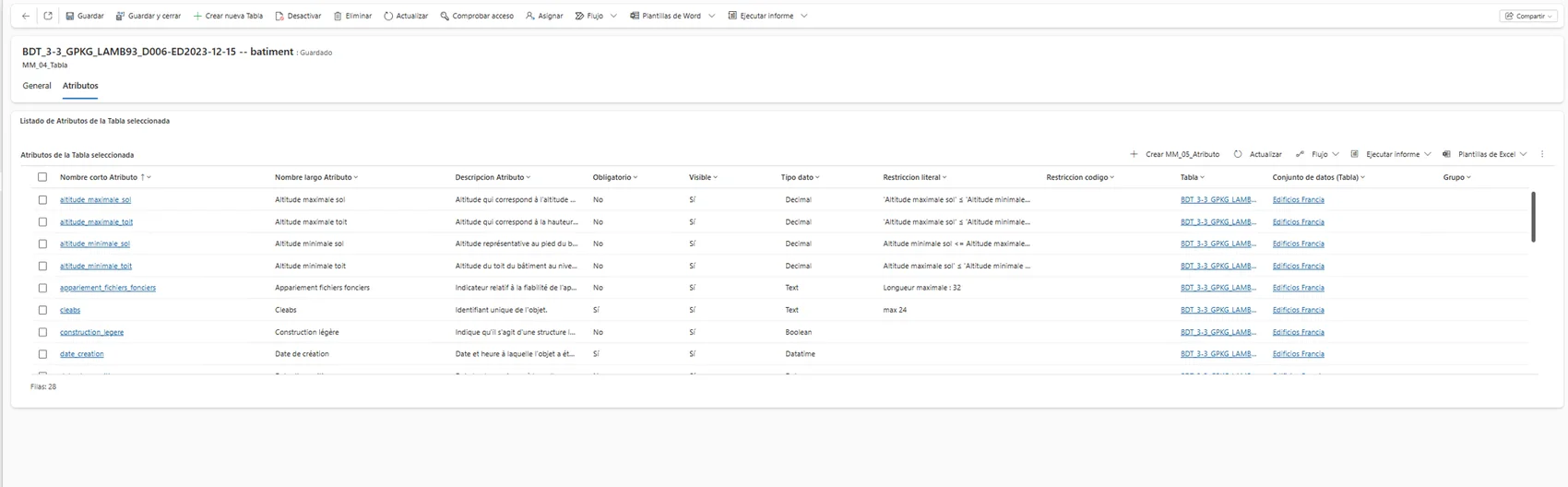
This is the batiment table of the BDTOPO France buildings model in MetaMod: 28 attributes with their type, mandatory flag, constraints and catalogues, ready to generate data dictionaries, specifications and reports consistent with the current version.
Real product screenshot
Share the knowledge, not the data
A direct consequence of governing the knowledge of the model: you can share it even when direct access to the original data is not possible for data protection, security, confidentiality, administrative competences or contractual reasons.
MetaMod lets you share the model that describes them:
- Its structure
- Its meaning
- Its rules
- Its relationships
- Its catalogues
- Its quality criteria
- Its update mechanisms
- Its conditions of use
Leverage AI without sending the data to the AI
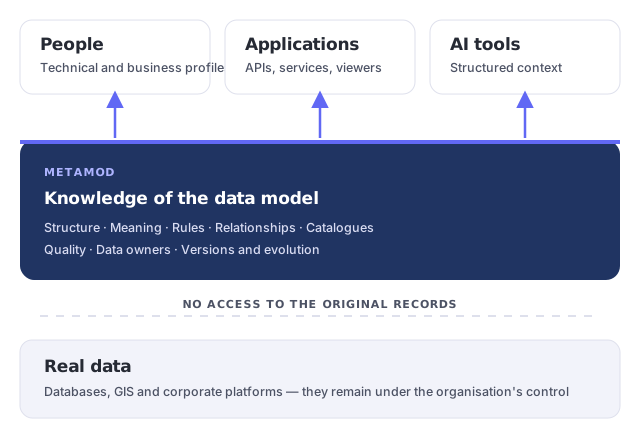
AI can query documentation, generate specifications, analyse models or speed up development. The problem appears when using it requires sharing real databases or sensitive information. MetaMod proposes a different approach: the AI works on the structured knowledge of the model, not necessarily on the stored data.
The AI works with…
Use cases it enables
- Query the information model in natural language
- Generate technical and functional documentation
- Detect inconsistencies between entities and attributes
- Propose mappings between models
- Prepare API structures
- Generate validation rules and test cases
- Assist in the development of software components
- Analyse the impact of changes
Geographic information demands more than attributes
A territorial element is not defined by its attributes alone: the geometry type, the reference system, the accuracy, the scale, the level of detail, the spatial relationships, the topological rules, the temporal evolution and the representation and publication formats all come into play. MetaMod structures this geospatial knowledge and relates it to the organisation's alphanumeric models, applications, services and processes.
Example: properly defining a road section
An identifier and a linear geometry are not enough. You may also need to establish:
- Where the section starts and ends
- How it connects to other sections
- Which rules guarantee network continuity
- Its direction of travel
- Which catalogue classifies its typology
- Which source is responsible for updates
- The geometric accuracy required
- How it is published in a viewer or service
- How it relates to other road models
Harmonisation of geographic models
Administrations and companies work with models from very diverse sources, which do not always share entities, attributes, catalogues or levels of detail. MetaMod documents their equivalences and differences: which concepts are comparable, which attributes correspond, which transformations to apply and which rules the resulting model must satisfy.
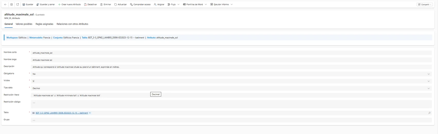
Real screenshot: a model attribute with its semantics and its consistency rule documented
It complements your platforms — it does not replace them
What your platforms already govern
Databases, GIS platforms and corporate data governance solutions are essential for storage, access, security, the technical catalogue, operational lineage, the quality of the real data, publication and exploitation. MetaMod does not aim to replace them.
The layer MetaMod adds
The definition and management of the knowledge associated with the model: understanding it, designing it and evolving it. This separation eases integration with the technologies already in place and avoids creating yet another information silo.
Corporate platforms govern the data assets; MetaMod structures the knowledge needed to understand, design and evolve them.
Built for those who govern and use data models
Public administrations
National, regional and local: territorial models, catalogues and interoperability between bodies and with partner organisations.
Consultancies & engineering firms
Our clients, never our competitors: they define and deliver quality models — documented and traceable — to their end clients.
Data owners
CDOs and data governance teams who need a knowledge and semantics layer on top of their corporate platforms.
GIS & IT teams
Those who design, migrate and integrate databases, services and applications, with or without a geospatial component.
Four situations where MetaMod makes the difference
Typical scenarios, based on the problems MetaMod is designed to solve.
Harmonisation across organisations
Several bodies share information about the same territory, each with its own model. MetaMod documents the equivalences between models and publishes the common knowledge, so exchanges are agreed on explicit definitions rather than interpretations.
Documenting a road network
A road network whose entities, catalogues, topological rules and data owners are spread across scattered documents. With the model structured in MetaMod, dictionaries and specifications are generated always consistent with the current version.
Impact analysis before changes
An attribute needs to change and nobody knows for certain which services, processes or applications depend on it. MetaMod traces those dependencies and shows the scope of the change before applying it, with the model under version control.
Semantic readiness for AI
The organisation wants to leverage AI on its information without exposing records. MetaMod gives the AI the structured context of the model — entities, rules, domains, semantics — to obtain useful answers while reducing the exposure of sensitive data.
The company that is expert in Geographic Intelligence
We know territorial data
Geograma is the company expert in Geographic Intelligence: capture, processing and management of geoinformation, GIS development and integration. A NavPro company. That is why MetaMod treats the geospatial dimension as a specialisation, not as an add-on.
We develop and integrate
We develop applications and integrate data and services on top of the technologies each organisation already runs. MetaMod is backed by public R&D programmes and is designed to complement — not duplicate — your corporate platforms.
You stay in control
We structure and operate the knowledge of your data so you can measure, justify and defend every decision. The client always decides: administrations, companies and the consultancies and engineering firms we work with, which are our clients, never our competitors.
A project backed by public innovation programmes
Support for business projects of industrial research and experimental development.
File no.: ZL-2025/00270Funding from Spain's Centre for the Development of Technology and Innovation through its R&D grants programme.
File no.: IDI-20250687What we are usually asked about MetaMod
Does MetaMod replace my database, my GIS or my data governance platform?
No. MetaMod sits in a complementary layer: the definition and management of the knowledge associated with the model. Corporate platforms govern the data assets; MetaMod structures the knowledge needed to understand, design and evolve them, integrating with the technologies already in place.
Do I have to grant access to the real data to work with MetaMod?
No. MetaMod works on the model that describes the data: its structure, meaning, rules, relationships, catalogues, quality criteria and update mechanisms. A department or partner organisation can understand what information exists and how to use it without accessing the original records.
How does it enable AI without sending the data to the AI?
The AI works on the structured knowledge of the model — entities, attributes, relationships, rules, domains, specifications — not necessarily on the stored records. This significantly reduces the exposure of sensitive information, although no use of AI is automatically safe in itself.
What can be described with MetaMod?
Entities and attributes, relationships and dependencies, value domains and catalogues, business rules and constraints, responsibilities and information sources, interfaces, services and processes, and the versions and evolution of the model.
Why is it specialised in geospatial information?
A territorial element is not defined by its attributes alone: geometry, reference system, accuracy, scale, spatial relationships, topological rules, temporal evolution and publication formats all come into play. MetaMod structures this knowledge and documents equivalences between models such as CartoCiudad, Spain's National Topographic Base, the Cadastre or SIOSE.
What happens when the model changes?
MetaMod keeps versions of the model and analyses the dependencies between its components: when an attribute is modified, the entities, interfaces, rules, processes or applications affected can be identified. This improves traceability and reduces the risk associated with the evolution of information systems.
Where can MetaMod be purchased?
MetaMod is available as a SaaS solution, with a free trial, on the Microsoft marketplace. You can also contact Geograma for a demo or to discuss a deployment tailored to your organisation.
Try MetaMod with your models
Tell us which models you manage — territorial, corporate or both — and in a hands-on session we will show you how MetaMod structures their knowledge, generates their documentation and prepares them for use with AI.