
The first souvenir a visitor takes home is your map.
We design and print artistic tourist maps: accurate cartography dressed in hand-drawn illustrations that guide the visitor, showcase every corner of your destination and become a keepsake worth holding on to. From the base cartography to the final print, we take care of everything.
- 250,000 copies · Donostia
- 4 formats · Bilbao
- Multilingual · EU ES EN FR
- Paper + QR
Not a plan: a work of art that guides
A good tourist map doesn't compete with the phone: it complements it. It doesn't try to replicate a navigation app, but to offer a visual, artistic representation of the territory that inspires and guides the visitor through the landmark spaces of the centre and also through the resources spread across the neighbourhoods.
That's where we're different. We hand-illustrate the monuments and the most recognisable landmarks, we create a graphic language of its own for each destination, and we take care of visual hierarchy, legibility, colour and aesthetics. The result is an attractive, functional and memorable tourist tool, easy to read for a wide audience, local and international —and beautiful enough to keep.
Many destinations are stuck with old maps, limited in size, clarity or ability to summarise. We renew them completely.
What an artistic tourist map by Geograma includes
Each map is conceived as a communication tool. A typical project brings together:
-
01
Accurate base cartography
Accurate, up-to-date urban base cartography, built from official data and designed not to compete with the tourist information, but to enhance it.
-
02
Artistic illustrations
Hand-drawn illustrations of the most emblematic monuments and buildings, and specific iconography by category for quick reading on the ground.
-
03
Inventory of tourist resources
Inventory and updating of monuments, museums, parks, leisure areas, natural spaces, routes and pedestrian access, along with practical services: hotels, tourist offices, train and bus stations, taxi ranks, car parks, public toilets…
-
04
Legends and enlargements
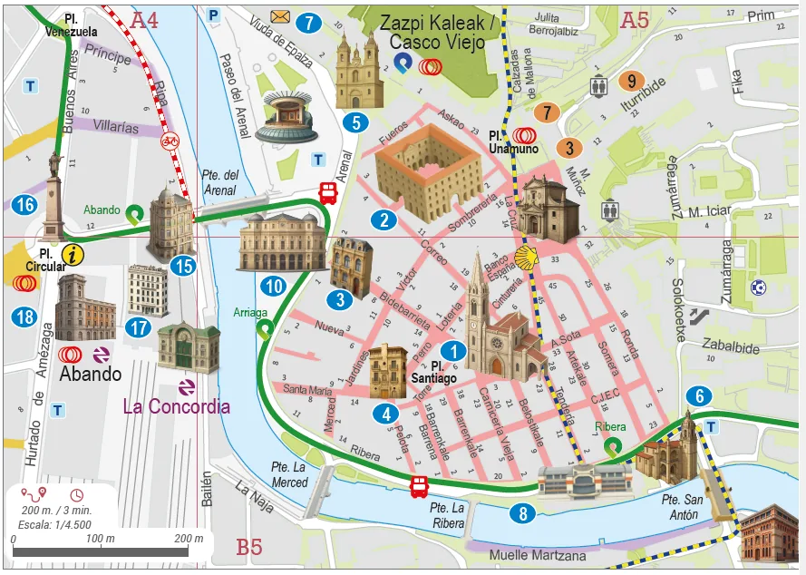
Clear legends and marginal elements, plus enlargements of the areas of greatest interest —for example, a historic quarter—.
-
05
QR codes
QR codes that connect the paper with always up-to-date digital content: websites, audio guides or interactive maps.
-
06
Multilingual as standard
Each map is produced in the language versions your destination needs, ensuring terminological consistency and linguistic quality across all of them.
For an international audience. We produce each map in Basque, Spanish, English, French or other languages. It's a key asset for tourist offices, institutional communication and projects with international reach.
- EU
- ES
- EN
- FR
- +
The format that best fits your channel
We adapt the product to the use and distribution channel, from mass handout to consultation or display.
-
Printed
From A4 pads and A3 format to large folded sheets, posters for tourist offices or adaptations for MUPIs (street furniture) in high-traffic areas. Professional full-colour printing, with advice on paper weight, folding and finishes.
-
Digital
Web PDF: basic, with layers you can toggle by language or element type, with links and pop-ups, or georeferenced GeoPDF.
-
Web
Online publication of the map to embed it in the destination's website and connect it with the rest of your digital channels.
All your destination's cartography, from a single author
The artistic tourist map is our flagship, but not the only piece. At Geograma we produce the full range of maps a territory needs, with the same rigour and the same care for design: consistent cartography and a single point of contact.
-
/01
Street or urban maps
Detailed representation of the environment to find your way around the city or the countryside.
-
/02
Route and itinerary maps
Trails, mountain or urban routes, with the practical information of each path.
-
/03
Toponymic maps
The municipality's place names collected and represented with rigour, for the city or the countryside.
-
/04
Transport and mobility maps
With experience such as the cartography for the Regional Transport Consortium of Madrid (CRTM).
-
/05
Environmental maps
The territory's natural spaces and environmental values, communicated with cartographic judgement.
-
/06
Custom thematic maps
Any reading of the territory your destination needs to tell, turned into a clear, attractive map.
How we work
We accompany the whole process, not just the design. Content is validated with you at each step to make sure everything is accurate, up to date and consistent.
-
Definition
Advice on choosing the right product for your goals and audience, and treatment and structuring of the source geographic information.
-
Development
Cartographic and illustrative design, translation and content coordination, with thorough quality control at every stage.
-
Deployment
Management of the final printing and adaptation to your destination's formats and distribution channels.
Destinations already guiding visitors with a signature map
A new map for today's visitor
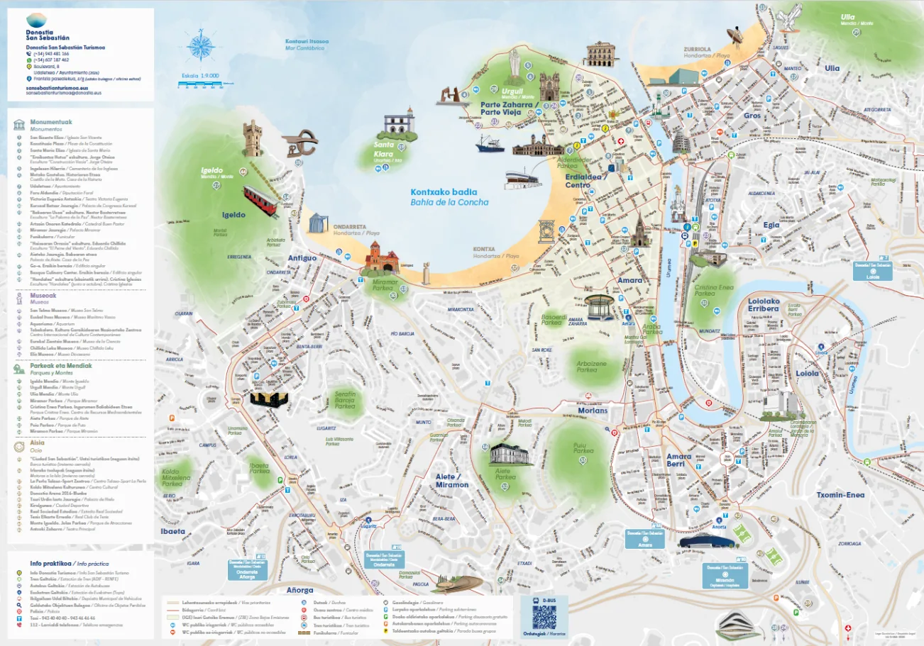
San Sebastián Turismo – Donostia Turismoa needed to completely renew its tourist map to adapt it to today's visitor behaviour and give prominence to the resources in every neighbourhood. We developed a new artistic tourist map combining cartographic accuracy, artistic illustrations of the monuments, category iconography and a hybrid paper + QR system.
- 250,000 copies
- 2 bilingual editions
- EU/ES · FR/EN
See the full case study →"We're very happy with Geograma's work. It's been a joy to work with the team; the collaboration was agile, close and highly professional. The new tourist map of San Sebastián exceeds what we expected. We're already using it in visitor services, where it's had a wonderful reception."
A more modern, visual and functional map
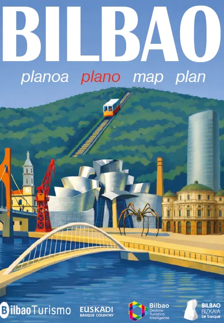
Bilbao Ekintza trusted Geograma to transform its tourist map into a more modern, visual and functional piece, with a better summary of the information and a more inclusive reading of the city. We created a new visual language, specific iconography, QR codes and an enlargement of the Old Town.
- 4 formats
- A4 · A3 · posters
- 4 languages
It was produced in four formats: A4 and A3 in several languages, plus two posters for tourist offices.
See the full case study →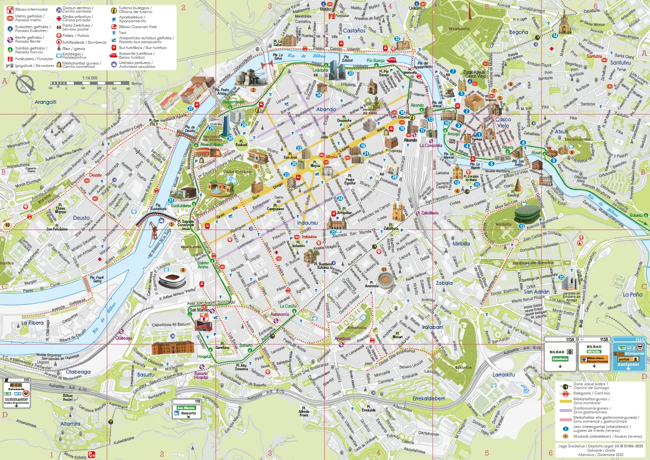
Design with cartographic rigour
-
01
+25 years of craft
More than 25 years turning complex geographic information into clear, accurate and attractive cartography.
-
02
In-house illustration and design
The artistic style is our signature, not an add-on. Each destination gets a graphic language created for it.
-
03
Real, recent experience
Landmark tourist maps (Donostia, Bilbao) and transport cartography for the Regional Transport Consortium of Madrid.
-
04
Design + technical rigour
We don't just represent information: we communicate it with cartographic judgement and graphic creativity.
-
05
Standardised yet flexible
We start from well-defined products to stay agile on time and budget, without giving up the personalisation of each destination.
-
06
Parametric budgeting
We price each project according to format, size, extent of the territory, population and the elements to be represented: a fast, consistent estimate.
Made for those who showcase their territory
- Tourist offices and promotion bodiesThe key piece of visitor services and destination communication.
- Town councilsA clear, artistic and attractive wayfinding tool for the municipality.
- Provincial councils and regionsConsistent cartography for the whole territory, from a single author.
- Other territorial organisationsAny organisation that wants to showcase its territory with a memorable map.
Frequently asked questions
What makes your tourist map "artistic"?
We hand-illustrate the monuments and landmarks of the destination and create a graphic language of its own, so the map isn't a utilitarian plan but an attractive visual piece the visitor wants to keep.
In how many languages can you produce the map?
In the versions you need —Basque, Spanish, English, French or others— ensuring terminological consistency across all of them.
In which formats do you deliver the map?
Printed (A4, A3, large folded sheets, posters, MUPIs) and digital (web PDF, layered or linked PDF, GeoPDF and web publication). We choose the format according to your distribution channel.
Do the maps include digital content?
Yes. We incorporate QR codes linking to websites, audio guides or interactive maps, connecting the paper with always up-to-date information.
Do you produce other types of map besides tourist maps?
Yes: street maps, route and itinerary maps, toponymic, transport and mobility, environmental and thematic maps. We can cover all your destination's cartography.
How is the budget calculated?
On a parametric basis, according to the format, size, extent of the territory, population and the elements to be represented, which lets us give you a fast and consistent estimate.
Let's talk about your destination
Tell us which territory you want to represent and in which format, and we'll prepare a tailored proposal.
Contact our team →