
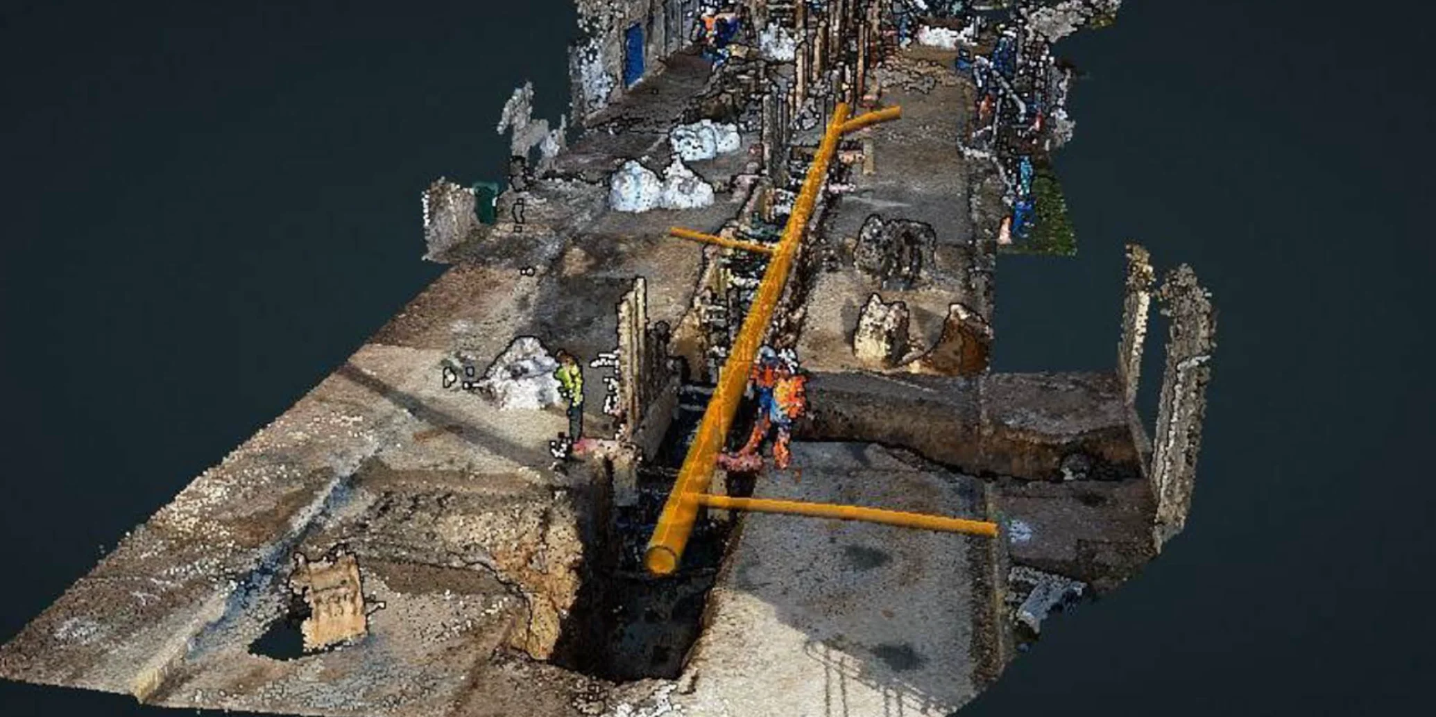
At Geograma, we have taken another step forward in our commitment to the democratisation of 3D geographic information. With the support of the Álava Innova 2025 programme, we have developed OpenTrench GIS, a comprehensive methodology for capturing, processing, georeferencing and integrating 3D information on underground utility networks into GIS systems at the critical moment when the trench is still open, using only a smartphoneand without the need for a surveyor on site.
The challenge: utility networks buried without being properly documented
Sewerage, water supply, electricity, gas and telecommunications networks are located underground, making them difficult to map and manage when their exact position is not accurately known. The best time to survey a utility network is while the trench is open and the ducts, pipes, sewers and other assets are being installed.
However, this opportunity only lasts for a short time, a surveyor is not always available, and traditional methods such as total stations, high-precision GNSS and laser scanners require specialist personnel and expensive equipment. As a result, network inventories all too often fail to accurately reflect what is actually buried underground.
The solution: record a video before the trench is closed
OpenTrench GIS turns utility network documentation into a procedure that can be carried out by any site operative, works inspector or municipal technician, in five steps:
- Record a video of the trench using a standard smartphone, including unchanged surroundings such as pavements, building façades and street furniture as reference features.
- Upload the video to the GeoCassini platform from any Internet-connected device.
- Process the video automatically using photogrammetry with the RezoCassini application, generating a colourised 3D point cloud within minutes.
- Georeference the point cloud online using control points with known coordinates or through cloud-to-cloud alignment against an existing Mobile Mapping survey.
- Measure and digitise pipes, sewers and other assets in 3D, assign attributes such as material, diameter and depth, and export them to the corporate GIS in standard formats including SHP, DXF, GeoPackage and LAS, ready for use in QGIS or ArcGIS.
- The methodology has been validated in two complementary scenarios: digitising a section of a utility network while the trench is open, and updating existing networks through the inspection of accessible manholes, making it possible to document networks even where opening a trench is not feasible.
Validated with public authorities and real users
To assess the interest in the solution and its operational feasibility, we have worked with the Donostia / San Sebastián City Council, a recognised reference in the use of point clouds for municipal management. The City Council has confirmed the suitability of the methodology for maintaining its utility network inventories.
The methodology has also been applied in a pilot project involving existing water supply and sewerage inventories, integrating newly digitised sections into the municipal GIS and assessing its ease of use by works inspectors, municipal technicians and asset inventory managers with no specialist surveying training.
A project supported by Álava Innova
The project “Development of a methodology for capturing GIS data on utility networks while the trench is open – OpenTrench GIS” has received funding from the Álava Innova 2025 programme, promoted by the Provincial Council of Álava to foster innovation and digital transformation across the region.
Thanks to this support, Geograma has been able to turn an idea into a real service, which is now available in our portfolio for public authorities and utility operators.
OpenTrench GIS: another step towards democratising point clouds
With OpenTrench GIS, any municipality, intermunicipal authority or utility operator can maintain a precise, traceable and up-to-date 3D inventory of its networks, reducing data capture costs and timescales while improving works planning and emergency response.
This project reinforces Geograma’s strategy: putting technology at the service of society and helping public institutions and businesses unlock the value of geographic information.
If you manage utility networks and would like to find out how OpenTrench GIS can be implemented in your organisation, contact us.