
At Geograma we have set to work on the biggest update of a cartographic base of the province of Gipuzkoa in the last 15 years. For this purpose, we use Mobile Mapping technology. We give you more details of these works and tell you why and how they are being carried out.
Some time ago we talked about the possibilities of Mobile Mapping (MoMA) technology to improve the accuracy of a 5,000 geographic base in this article. Well, today we have to tell you that Geograma is involved in a project in which this technology has been applied to the road network of the Historical Territory of Gipuzkoa.
Specifically, the aim of the project is to replace in the cartographic base of Gipuzkoa the information relating to its roads through the data obtained by means of Mobile Mapping surveys.
What are these works intended to achieve?
The significance of this project lies in its size: a total of 1,723 km of roads are being replaced, which will be the largest update of this provincial cartographic base in the last 15 years.
Thanks to this methodology, at the end of the process, it will be possible to guarantee an accuracy of approximately 10 centimetres on all roads in the province. This means reducing to a tenth of a metre the one-metre margin of error that characterised the roads restituted in rural areas, both in X and Y coordinates, as well as in elevation.
This significant improvement in the quality of the data will mean a qualitative leap in the reliability of the cartographic base, facilitating future possible applications, such as its use for navigation and the search for faster routes for emergency response.
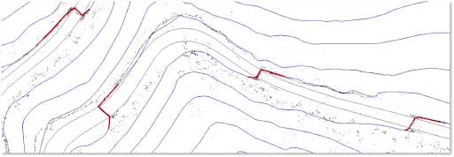
Methodology used
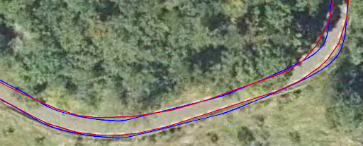
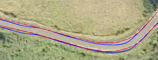
On the one hand, the edges of the carriageways drawn by restitution at a scale of 5,000 are being replaced by the white lines extracted from the data obtained. At the same time, the correction of the contour lines along these roads, the extraction of new elevation points and the replacement of the previous ones are being carried out.
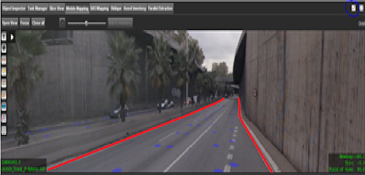
The methodology used consisted, firstly, of extracting the white lines of road edges using semi-automatic extraction tools and integrating them into the cartography, replacing the previous road edges.
For the improvement of the contour lines, an image has been generated with the LiDAR points coinciding with the elevations of the contour lines of the altimetric base, and the contour lines are being adapted to these elevation points.
Finally, by means of an automatic process, the pre-existing road elevation points in the cartography are being superimposed with the LiDAR point cloud obtained from the Mobile Mapping survey, carrying out an extraction for each one of them. All that remains is to replace the previous points with these new ones.
This work opens up a world of possibilities for the massive improvement of mapping on a regional scale. The application of dynamic surveys is increasing all the time. From Geograma, we will keep you informed of all the MoMa projects in which we participate. Keep your eyes open!